
Geary topographic map
Interactive map
Click on the map to display elevation.
About this map
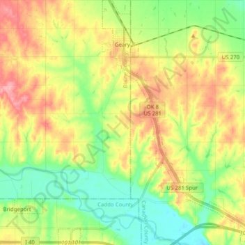
Name: Geary topographic map, elevation, terrain.
Location: Geary, Blaine County, Oklahoma, 73040, United States (35.52784 -98.33116 35.65277 -98.21972)
Average elevation: 459 m
Minimum elevation: 414 m
Maximum elevation: 517 m
Other topographic maps
Click on a map to view its topography, its elevation and its terrain.
Greenfield
United States > Oklahoma > Blaine County
Greenfield, Blaine County, Oklahoma, United States
Average elevation: 452 m
Okeene
United States > Oklahoma > Blaine County
Okeene, Blaine County, Oklahoma, 73763, United States
Average elevation: 369 m
Canton Lake
United States > Oklahoma > Blaine County
Canton Lake, Blaine County, Oklahoma, United States
Average elevation: 502 m
Watonga
United States > Oklahoma > Blaine County
Watonga, Blaine County, Oklahoma, 73772, United States
Average elevation: 467 m