
Lac Gamache topographic map
Interactive map
Click on the map to display elevation.
About this map
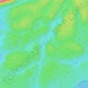
Name: Lac Gamache topographic map, elevation, terrain.
Average elevation: 116 m
Minimum elevation: 68 m
Maximum elevation: 239 m
Other topographic maps
Click on a map to view its topography, its elevation and its terrain.
Baie Saguenay
Baie Saguenay, Sept-Îles, Sept-Rivières, Côte-Nord, Québec, Canada
Average elevation: 163 m
Rivière Moisie
Rivière Moisie, Sept-Îles, Sept-Rivières, Côte-Nord, Québec, Canada
Average elevation: 182 m
Lac Labrie
Lac Labrie, Sentier motoneige Station Gallix, Sept-Îles, Sept-Rivières, Côte-Nord, Québec, Canada
Average elevation: 105 m