
Gary topographic map
Interactive map
Click on the map to display elevation.
About this map
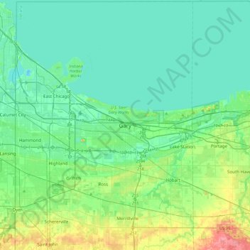
Name: Gary topographic map, elevation, terrain.
Location: Gary, Lake County, Indiana, 46402, United States (41.44213 -87.49714 41.76213 -87.17714)
Average elevation: 187 m
Minimum elevation: 170 m
Maximum elevation: 251 m
Other topographic maps
Click on a map to view its topography, its elevation and its terrain.
Miller
United States > Indiana > Lake County > Gary
Miller, Miller Beach, Gary, Calumet Township, Lake County, Indiana, 46403, United States
Average elevation: 186 m
Grand Calumet River
United States > Indiana > Lake County > Gary
Grand Calumet River, Gary, Thornton Township, Lake County, Indiana, United States
Average elevation: 180 m