
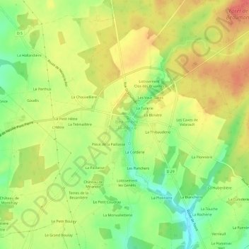
La Blonderie topographic map
Interactive map
Click on the map to display elevation.
About this map
Name: La Blonderie topographic map, elevation, terrain.
Average elevation: 131 m
Minimum elevation: 97 m
Maximum elevation: 160 m
Other topographic maps
Click on a map to view its topography, its elevation and its terrain.
La Mondinerie
France > Centre-Val de Loire > Indre-et-Loire > Beaumont-Louestault > La Mondinerie
La Mondinerie, Beaumont-la-Ronce, Beaumont-Louestault, Chinon, Indre-et-Loire, Centre-Val de Loire, France métropolitaine, 37360, France
Average elevation: 127 m
La Corderie
France > Centre-Val de Loire > Indre-et-Loire > Beaumont-Louestault
La Corderie, Beaumont-la-Ronce, Beaumont-Louestault, Chinon, Indre-et-Loire, Centre-Val de Loire, France métropolitaine, 37360, France
Average elevation: 130 m
La Logerie
France > Centre-Val de Loire > Indre-et-Loire > Beaumont-Louestault
La Logerie, Beaumont-la-Ronce, Beaumont-Louestault, Chinon, Indre-et-Loire, Centre-Val de Loire, France métropolitaine, 37360, France
Average elevation: 118 m
Château de Beaumont
France > Centre-Val de Loire > Indre-et-Loire > Beaumont-Louestault > St-Armel
Château de Beaumont, Rue du 8 Mai 1945, St-Armel, Beaumont-la-Ronce, Beaumont-Louestault, Chinon, Indre-et-Loire, Centre-Val de Loire, France métropolitaine, 37360, France
Average elevation: 132 m