Geolocate

派镇 topographic map

Interactive map

Click on the map to display elevation.

About this map

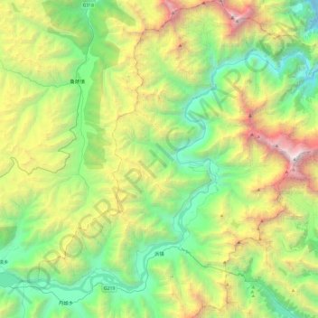
Name: 派镇 topographic map, elevation, terrain.

Location: 派镇, 米林县, 林芝市, 西藏自治区, 中国 (29.42197 94.77931 29.83983 95.20817)

Average elevation: 4,078 m

Minimum elevation: 2,460 m

Maximum elevation: 7,637 m

Other topographic maps

Click on a map to view its topography, its elevation and its terrain.

达林村

中国 > 西藏自治区 > 米林县 > 派镇

达林村, 派镇, 米林县, 林芝市, 西藏自治区, 中国

Average elevation: 3,286 m

丹娘乡

中国 > 西藏自治区 > 米林县

丹娘乡, 米林县, 林芝市, 西藏自治区, 中国

Average elevation: 3,868 m

米林县

中国 > 西藏自治区 > 米林县 > 米林镇

米林县, 米林镇, 米林县, 林芝市, 西藏自治区, 中国

Average elevation: 3,847 m

玉松村

中国 > 西藏自治区 > 米林县 > 派镇 > 玉松村

玉松村, 派镇, 米林县, 林芝市, 西藏自治区, 中国

Average elevation: 3,136 m

南迦巴瓦峰

中国 > 西藏自治区 > 米林县 > 派镇

南迦巴瓦峰, 派镇, 米林县, 林芝市, 西藏自治区, 中国

Average elevation: 6,698 m

羌纳乡

中国 > 西藏自治区 > 米林县

羌纳乡, 米林县, 林芝市, 西藏自治区, 中国

Average elevation: 3,790 m