
Yerevan topographic map
Interactive map
Click on the map to display elevation.
About this map
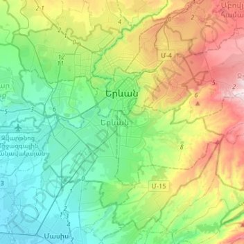
Name: Yerevan topographic map, elevation, terrain.
Location: Yerevan, Armenia (40.06585 44.36211 40.24177 44.62177)
Average elevation: 1,094 m
Minimum elevation: 826 m
Maximum elevation: 1,701 m
Other topographic maps
Click on a map to view its topography, its elevation and its terrain.
Lake Sevan
Armenia > Gegharkunik Province
Lake Sevan, Gegharkunik Province, Armenia
Average elevation: 2,025 m
Garni
Armenia > Kotayk Province > Garni village
Garni, Garni village, Garni Region, Kotayk Province, 2215, Armenia
Average elevation: 1,533 m
Gndevaz
Armenia > Vayots Dzor Province
Gndevaz, Jermuk Community, Vayots Dzor Province, Armenia
Average elevation: 1,771 m
Gyumri
Armenia > Shirak Province > Gyumri
Gyumri, Border Gyumri, Shirak Province, 3104, Armenia
Average elevation: 1,711 m