
San Clemente topographic map
Interactive map
Click on the map to display elevation.
About this map
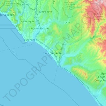
Name: San Clemente topographic map, elevation, terrain.
Average elevation: 123 m
Minimum elevation: 0 m
Maximum elevation: 978 m
Other topographic maps
Click on a map to view its topography, its elevation and its terrain.
Palisades Reservoir
United States > California > Orange County > San Clemente
Palisades Reservoir, San Clemente, Orange County, CAL Fire Southern Region, California, United States
Average elevation: 101 m