
Thank you for supporting this site ❤️
Make a donation
Make a donation
Bhadravathi topographic map
Click on the map to display elevation.
Thank you for supporting this site ❤️
Make a donation
Make a donation
Bhadravathi
Bhadravati is at an altitude of 597 metres (1,959 ft) above sea level.
Thank you for supporting this site ❤️
Make a donation
Make a donation
About this map
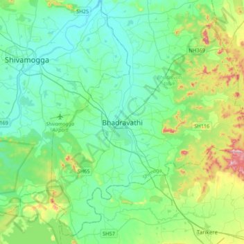
Name: Bhadravathi topographic map, elevation, terrain.
Average elevation: 642 m
Minimum elevation: 556 m
Maximum elevation: 960 m
Thank you for supporting this site ❤️
Make a donation
Make a donation