
Redhouse topographic map
Interactive map
Click on the map to display elevation.
About this map
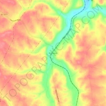
Name: Redhouse topographic map, elevation, terrain.
Location: Redhouse, Madison County, Kentucky, United States (37.81230 -84.29215 37.85230 -84.25215)
Average elevation: 248 m
Minimum elevation: 192 m
Maximum elevation: 279 m
Other topographic maps
Click on a map to view its topography, its elevation and its terrain.
Berea
United States > Kentucky > Madison County
Berea, Madison County, Kentucky, United States
Average elevation: 300 m
Newby
United States > Kentucky > Madison County
Newby, Madison County, Kentucky, United States
Average elevation: 272 m
Welch Mountain
United States > Kentucky > Madison County
Welch Mountain, Madison County, Kentucky, 40404, United States
Average elevation: 315 m
Fort Boonesborough State Park
United States > Kentucky > Madison County > Boonesborough
Fort Boonesborough State Park, Boonesborough, Madison County, Kentucky, United States
Average elevation: 236 m
Richmond
United States > Kentucky > Madison County
Richmond, Madison County, Kentucky, 40475, United States
Average elevation: 281 m
Berea
United States > Kentucky > Madison County > Berea > Berea
Berea, Madison County, Kentucky, 40404, United States
Average elevation: 314 m
Richmond
United States > Kentucky > Madison County > Richmond
Richmond, Madison County, Kentucky, 40475, United States
Average elevation: 267 m