
Queechy topographic map
Interactive map
Click on the map to display elevation.
About this map
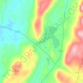
Name: Queechy topographic map, elevation, terrain.
Average elevation: 347 m
Minimum elevation: 248 m
Maximum elevation: 493 m
Other topographic maps
Click on a map to view its topography, its elevation and its terrain.
Red Rock
United States > New York > Columbia County > Town of Canaan
Red Rock, Town of Canaan, Columbia County, New York, 12165, United States
Average elevation: 331 m
Canaan Center
United States > New York > Columbia County > Town of Canaan
Canaan Center, Town of Canaan, Columbia County, New York, 12029, United States
Average elevation: 330 m
Flatbrook
United States > New York > Columbia County > Town of Canaan
Flatbrook, Town of Canaan, Columbia County, New York, 12029, United States
Average elevation: 357 m