
Thank you for supporting this site ❤️
Make a donation
Make a donation
Sangdong-ri topographic map
Click on the map to display elevation.
Thank you for supporting this site ❤️
Make a donation
Make a donation
About this map
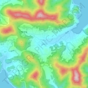
Name: Sangdong-ri topographic map, elevation, terrain.
Location: Sangdong-ri, Wando-gun, South Jeolla, 59151, South Korea (34.15793 126.87201 34.19793 126.91201)
Average elevation: 117 m
Minimum elevation: 0 m
Maximum elevation: 356 m
Thank you for supporting this site ❤️
Make a donation
Make a donation