
Tilton topographic map
Interactive map
Click on the map to display elevation.
About this map
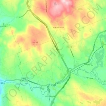
Name: Tilton topographic map, elevation, terrain.
Location: Tilton, Belknap County, New Hampshire, United States (43.43489 -71.62881 43.50224 -71.51075)
Average elevation: 196 m
Minimum elevation: 85 m
Maximum elevation: 356 m
Other topographic maps
Click on a map to view its topography, its elevation and its terrain.
Lake Winnipesaukee
United States > New Hampshire > Belknap County > Alton
Lake Winnipesaukee, Alton, Belknap County, New Hampshire, 03226, United States
Average elevation: 223 m
The Plains
United States > New Hampshire > Belknap County > Tilton
The Plains, Tilton, Belknap County, New Hampshire, 03252, United States
Average elevation: 167 m
Mallard Cove
United States > New Hampshire > Belknap County > Laconia
Mallard Cove, Laconia, Belknap County, New Hampshire, 03246, United States
Average elevation: 173 m
Sanbornton
United States > New Hampshire > Belknap County
Sanbornton, Belknap County, New Hampshire, 03269, United States
Average elevation: 228 m
Gilford
United States > New Hampshire > Belknap County
Gilford, Belknap County, New Hampshire, 03249, United States
Average elevation: 231 m
Meredith
United States > New Hampshire > Belknap County
Meredith, Belknap County, New Hampshire, 03253, United States
Average elevation: 215 m
Barnstead
United States > New Hampshire > Belknap County
Barnstead, Belknap County, New Hampshire, United States
Average elevation: 221 m