
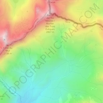
Lacs d'Agnel topographic map
Interactive map
Click on the map to display elevation.
About this map
Name: Lacs d'Agnel topographic map, elevation, terrain.
Average elevation: 2,385 m
Minimum elevation: 2,055 m
Maximum elevation: 2,849 m
Other topographic maps
Click on a map to view its topography, its elevation and its terrain.
La Rougna
France > Provence-Alpes-Côte d'Azur > Saint-Dalmas-le-Selvage
La Rougna, Saint-Dalmas-le-Selvage, Nice, Alpes-Maritimes, Provence-Alpes-Côte d'Azur, France métropolitaine, 06660, France
Average elevation: 2,248 m
Cime de la Bonette
France > Provence-Alpes-Côte d'Azur > Saint-Dalmas-le-Selvage
Cime de la Bonette, Saint-Dalmas-le-Selvage, Nice, Alpes-Maritimes, Provence-Alpes-Côte d'Azur, France métropolitaine, 06660, France
Average elevation: 2,510 m
Col d'Anelle
France > Provence-Alpes-Côte d'Azur > Saint-Dalmas-le-Selvage
Col d'Anelle, M 63, Saint-Dalmas-le-Selvage, Nice, Alpes-Maritimes, Provence-Alpes-Côte d'Azur, France métropolitaine, 06660, France
Average elevation: 1,696 m