
Валдайский район topographic map
Interactive map
Click on the map to display elevation.
About this map
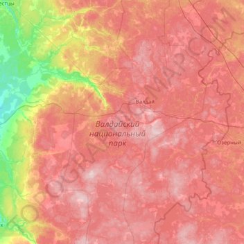
Name: Валдайский район topographic map, elevation, terrain.
Average elevation: 178 m
Minimum elevation: 41 m
Maximum elevation: 289 m
Other topographic maps
Click on a map to view its topography, its elevation and its terrain.
Мста
Russland > Oblast Nowgorod > Савинское сельское поселение
Мста, Савинское сельское поселение, Rajon Nowgorod, Oblast Nowgorod, Föderationskreis Nordwest, Russland
Average elevation: 19 m