
Make a donation
Weza Forest topographic map
Click on the map to display elevation.
Make a donation
Weza Forest
Areas of forest which grow in KwaZulu-Natal, South Africa mostly on south facing slopes in higher rainfall areas, and along the humid coastal areas. Different types of forest can be identified by their species composition which depends mostly on the altitude, latitude and substrate (soil and rock types) in which they grow. South facing slopes are favourable for the development of forest as they are more shaded, and therefore cooler and retain more moisture than the northern slopes. The extra moisture on the south slopes is not only favoured by forest trees, but also helps to prevent or subdue wildfires. Fires can also be blocked by cliff faces and rocks or boulders on these slopes, and by streams or rivers at the base of the slopes. The coastal regions are conducive to forest formation, because of high rainfall and humidity which are favoured by forest trees and also help to prevent or subdue fires. The rivers of the coastal areas are also broader than further inland, which may often prevent fires from spreading long distances, and fires generally burn uphill and therefore more often away from areas at low altitude.
Make a donation
About this map
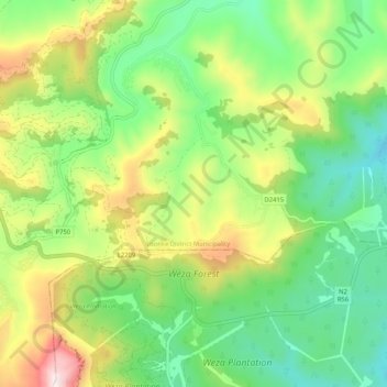
Name: Weza Forest topographic map, elevation, terrain.
Average elevation: 1,317 m
Minimum elevation: 1,021 m
Maximum elevation: 1,849 m
Make a donation
Other topographic maps
Click on a map to view its topography, its elevation and its terrain.
Harding
South Africa > KwaZulu-Natal > Ugu District Municipality > uMuziwabantu Local Municipality
Average elevation: 878 m
Harding
South Africa > KwaZulu-Natal > Ugu District Municipality > uMuziwabantu Local Municipality
Average elevation: 878 m