
Make a donation
Beaufou topographic map
Click on the map to display elevation.
Make a donation
Beaufou
The municipal territory of Beaufou covers 2,798 hectares. The average altitude of the municipality is 62 meters, with height fluctuating between 28 and 74 meters.
Make a donation
About this map
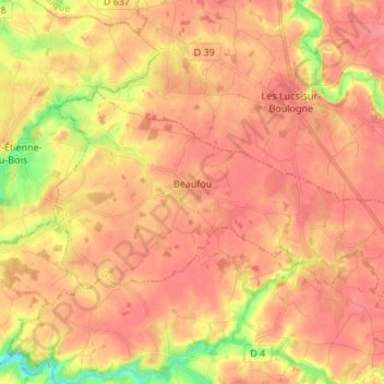
Name: Beaufou topographic map, elevation, terrain.
Average elevation: 59 m
Minimum elevation: 19 m
Maximum elevation: 74 m
Make a donation
Other topographic maps
Click on a map to view its topography, its elevation and its terrain.
La Grande Richardière
France > Pays de la Loire > Vendée > Aubigny-Les Clouzeaux > Les Clouzeaux
Average elevation: 54 m
La Chervinière
France > Pays de la Loire > Vendée > Rives-du-Fougerais > Saint-Sulpice-en-Pareds
Average elevation: 87 m
Make a donation
Make a donation
La Boutinardière
France > Pays de la Loire > Vendée > Chanverrie > Chambretaud
Average elevation: 200 m
Make a donation
Mareuil-sur-Lay-Dissais
France > Pays de la Loire > Vendée > Mareuil-sur-Lay-Dissais > Mareuil-sur-Lay-Dissais
Average elevation: 27 m
Saint-Maurice-des-Noues
France > Pays de la Loire > Vendée > Saint-Maurice-des-Noues > Saint-Maurice-des-Noues
Average elevation: 101 m
Make a donation