
Thank you for supporting this site ❤️
Make a donation
Make a donation
Lake Geneva topographic map
Click on the map to display elevation.
Thank you for supporting this site ❤️
Make a donation
Make a donation
Lake Geneva
According to the Swiss Federal Office of Topography, Swisstopo, Lac de Genève designates that part of the Petit Lac, which lies within the cantonal borders of Geneva (excluding the cantonal exclave Céligny), so about from Versoix–Hermance to the Rhône outflow in Geneva.
Thank you for supporting this site ❤️
Make a donation
Make a donation
About this map
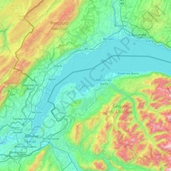
Name: Lake Geneva topographic map, elevation, terrain.
Average elevation: 798 m
Minimum elevation: 354 m
Maximum elevation: 2,445 m
Thank you for supporting this site ❤️
Make a donation
Make a donation
Other topographic maps
Click on a map to view its topography, its elevation and its terrain.