
Kenilworth topographic map
Interactive map
Click on the map to display elevation.
About this map
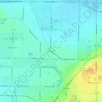
Name: Kenilworth topographic map, elevation, terrain.
Average elevation: 192 m
Minimum elevation: 183 m
Maximum elevation: 217 m
Other topographic maps
Click on a map to view its topography, its elevation and its terrain.
Brighton
United States > New York > Erie County > Town of Tonawanda
Brighton, Town of Tonawanda, Erie County, New York, 14223, United States
Average elevation: 182 m
Green Acres Valley
United States > New York > Erie County > Town of Tonawanda
Green Acres Valley, Town of Tonawanda, Erie County, New York, 14150, United States
Average elevation: 178 m