
Datag topographic map
Interactive map
Click on the map to display elevation.
About this map
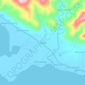
Name: Datag topographic map, elevation, terrain.
Location: Datag, San Andres, Catanduanes, Bicol Region, Philippines (13.59450 124.05354 13.63450 124.09354)
Average elevation: 53 m
Minimum elevation: -1 m
Maximum elevation: 341 m
Other topographic maps
Click on a map to view its topography, its elevation and its terrain.
Lictin
Philippines > Catanduanes > San Andres > San Andres
Lictin, San Andres, Catanduanes, Bicol Region, 4810, Philippines
Average elevation: 102 m
Batong Paloway
Philippines > Catanduanes > San Andres > San Andres
Batong Paloway, San Andres, Catanduanes, Bicol Region, 4810, Philippines
Average elevation: 73 m