
Scaffold Mountain topographic map
Interactive map
Click on the map to display elevation.
About this map
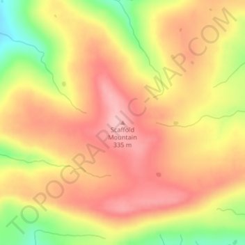
Name: Scaffold Mountain topographic map, elevation, terrain.
Location: Scaffold Mountain, Pittsburg County, Oklahoma, United States (35.09116 -95.58115 35.09126 -95.58105)
Average elevation: 283 m
Minimum elevation: 194 m
Maximum elevation: 335 m
Other topographic maps
Click on a map to view its topography, its elevation and its terrain.
Buck Hill
United States > Oklahoma > Pittsburg County
Buck Hill, Pittsburg County, Oklahoma, 74522, United States
Average elevation: 210 m
Hartshorne
United States > Oklahoma > Pittsburg County
Hartshorne, Pittsburg County, Oklahoma, 74547, United States
Average elevation: 213 m