
Washington topographic map
Interactive map
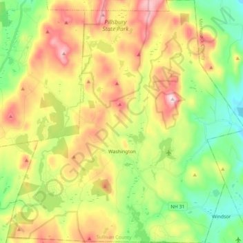
Click on the map to display elevation.
About this map
Name: Washington topographic map, elevation, terrain.
Average elevation: 466 m
Minimum elevation: 265 m
Maximum elevation: 742 m
Lovewell Mountain, located northeast of the town center and with an elevation of 2,496 feet (761 m), is the highest point in town. As Edwin A. Charlton writes in New Hampshire As It Is (1855), the mountain "received its name from Captain John Lovewell, who was accustomed to ascend it for the purpose of discovering the wigwams of the Indians, and who, on one occasion, killed seven Indians near its summit." The Washington Town Common, elevation 1,507 feet (459 m), is the highest town center in the state. (The town hall of Clarksville in northern New Hampshire is located at a higher elevation—1,980 feet (600 m)—but there is no other village development there.)
Other topographic maps
Click on a map to view its topography, its elevation and its terrain.
Plainfield
United States > New Hampshire > Sullivan County
Plainfield, Sullivan County, New Hampshire, United States
Average elevation: 267 m
Unity
United States > New Hampshire > Sullivan County
Unity, Sullivan County, New Hampshire, United States
Average elevation: 369 m
Lempster
United States > New Hampshire > Sullivan County
Lempster, Sullivan County, New Hampshire, 03605, United States
Average elevation: 425 m
Springfield
United States > New Hampshire > Sullivan County > Springfield
Springfield, Sullivan County, New Hampshire, United States
Average elevation: 416 m
Charlestown
United States > New Hampshire > Sullivan County
Charlestown, Sullivan County, New Hampshire, 03603, United States
Average elevation: 256 m
Claremont
United States > New Hampshire > Sullivan County
Claremont, Sullivan County, New Hampshire, United States
Average elevation: 236 m