
Cantal topographic map
Interactive map
Click on the map to display elevation.
Cantal
Cantal lies in the middle of France's central plateau. The Cantal range is a group of extinct and eroded volcanic peaks. Its highest point is the Plomb du Cantal, which reaches an elevation of 1,858 meters (6,096 ft). Its neighbors are Puy Mary (elev. 1,787 meters or 5,863 feet) and Puy Chavaroche (elev. 5,722 feet or 1,744 meters). To their north lie the Cézallier and Dore ranges and the arid Artense Plateau. Immediately to their east is the fertile Planèze Plateau, bound on its east by the Monts de la Margeride.
About this map
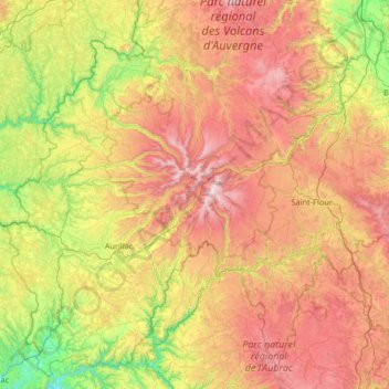
Name: Cantal topographic map, elevation, terrain.
Location: Cantal, Auvergne-Rhône-Alpes, Metropolitan France, France (44.61593 2.06290 45.48356 3.37129)
Average elevation: 825 m
Minimum elevation: 183 m
Maximum elevation: 1,810 m
Other topographic maps
Click on a map to view its topography, its elevation and its terrain.
Mont Blanc / Monte Bianco
France > Auvergne-Rhône-Alpes > Upper Savoy > Saint-Gervais-les-Bains
The climate is cold and temperate (Köppen climate classification Cfb), and is greatly influenced by altitude. Being the highest part of the Alps, Mont Blanc and surrounding mountains can create their own weather patterns. Temperatures drop as the mountains gain in height, and the summit of Mont Blanc is a…
Average elevation: 4,092 m
Le Chapet
France > Auvergne-Rhône-Alpes > Savoy > La Giettaz > La Giettaz-en-Aravis
Average elevation: 1,397 m
Mont Joly
France > Auvergne-Rhône-Alpes > Upper Savoy > Saint-Gervais-les-Bains
Average elevation: 1,978 m
Aiguille du Midi
France > Auvergne-Rhône-Alpes > Upper Savoy > Chamonix-Mont-Blanc
The span of the second section is 2,867 m (1.781 mi) measured directly, but only 2,500 m (1.6 mi) measured horizontally. Thus it remains the second longest span width, measured directly. The cable car travels from Chamonix to the top of the Aiguille du Midi – an altitude gain of over 2,800 m (9,200 ft) –…
Average elevation: 3,098 m
Flaine
France > Auvergne-Rhône-Alpes > Upper Savoy
The site is divided into two areas which are joined by two free lifts. The upper area, Flaine Forêt, at an altitude of 1700 m, consists of a number of apartment buildings named after constellations, the Éric et Sylvie Boissonnas Auditorium, shops, offices and restaurants. The lower area, Flaine Forum, at an…
Average elevation: 1,850 m
Laniac
France > Auvergne-Rhône-Alpes > Haute-Loire > Siaugues-Sainte-Marie > Siaugues-Saint-Romain
Average elevation: 909 m
Beaune-le-Chaud
France > Auvergne-Rhône-Alpes > Puy-de-Dôme > Saint-Genès-Champanelle
Average elevation: 941 m
Glacier de la Grande Casse
France > Auvergne-Rhône-Alpes > Savoy > Pralognan-la-Vanoise
Average elevation: 2,896 m
Les Brunières
France > Auvergne-Rhône-Alpes > Isère > Saint-Quentin-sur-Isère
Average elevation: 423 m
Villard-Bernon
France > Auvergne-Rhône-Alpes > Savoy > Saint-Michel-de-Maurienne
Average elevation: 1,155 m
Les Plans
France > Auvergne-Rhône-Alpes > Upper Savoy > Chamonix-Mont-Blanc
Average elevation: 1,416 m
Vers le Nant
France > Auvergne-Rhône-Alpes > Upper Savoy > Chamonix-Mont-Blanc > Les Bossons
Average elevation: 1,357 m
Hameau des Farlaix
France > Auvergne-Rhône-Alpes > Isère > Autrans-Méaudre en Vercors > Méaudre
Average elevation: 1,155 m
Parc de la Tête d'Or
France > Auvergne-Rhône-Alpes > Métropole de Lyon > Lyon
Average elevation: 189 m
Les Gicons
France > Auvergne-Rhône-Alpes > Puy-de-Dôme > Montaigut-en-Combraille
Average elevation: 608 m
Parc Sergent Blandan
France > Auvergne-Rhône-Alpes > Métropole de Lyon > Lyon
Average elevation: 174 m
Villarabout
France > Auvergne-Rhône-Alpes > Savoy > Saint-Martin-de-Belleville
Average elevation: 1,600 m
Cheneville
France > Auvergne-Rhône-Alpes > Haute-Loire > Varennes-Saint-Honorat
Average elevation: 1,055 m
Val Thorens
France > Auvergne-Rhône-Alpes > Savoy
Val Thorens ([val tɔʁɑ̃]) is a ski town in the Tarentaise Valley in the French Alps at an altitude of 2,300 m (7,500 ft). It is located in the commune of Saint-Martin-de-Belleville in the Savoie department. The resort forms part of the Les Trois Vallées ski area which, with over 600 km of slopes, is one…
Average elevation: 2,516 m
Montenvers
France > Auvergne-Rhône-Alpes > Upper Savoy > Chamonix-Mont-Blanc
Average elevation: 1,801 m
Les Frasserands
France > Auvergne-Rhône-Alpes > Upper Savoy > Chamonix-Mont-Blanc > Argentière
Average elevation: 1,704 m
Argentière
France > Auvergne-Rhône-Alpes > Upper Savoy > Chamonix-Mont-Blanc
Argentière (French pronunciation: [aʁʒɑ̃tjɛʁ]) is a picturesque skiing, alpine walking and mountaineering village in the French Alps, part of the commune of Chamonix-Mont-Blanc, at an altitude of 1,252 m (4,108 ft).
Average elevation: 1,674 m
Lac de serre
France > Auvergne-Rhône-Alpes > Cantal > Saint-Saturnin > Le Fayet
Average elevation: 1,148 m
Saint-Nicolas-de-Véroce
France > Auvergne-Rhône-Alpes > Upper Savoy > Saint-Gervais-les-Bains
Average elevation: 1,340 m
Mer de Glace
France > Auvergne-Rhône-Alpes > Upper Savoy > Chamonix-Mont-Blanc
The glacier lies above the Chamonix valley. The pressure within the ice is known to reach at least 30 atmospheres. The Mer de Glace can be considered as originating at an elevation of 2,100 metres (6,900 ft), just north of the Aiguille du Tacul, where it is formed by the confluence of the Glacier de Leschaux…
Average elevation: 2,323 m
La Live
France > Auvergne-Rhône-Alpes > Puy-de-Dôme > Glaine-Montaigut > Glaine
Average elevation: 363 m
Soulace
France > Auvergne-Rhône-Alpes > Puy-de-Dôme > Marsac-en-Livradois > Flaittes
Average elevation: 621 m
Hameau de Romanieux
France > Auvergne-Rhône-Alpes > Ardèche > Saint-Alban-d'Ay
Average elevation: 710 m
Praranger
France > Auvergne-Rhône-Alpes > Savoy > Saint-Martin-de-Belleville
Average elevation: 1,867 m
Plagne Villages
France > Auvergne-Rhône-Alpes > Savoy > La Plagne-Tarentaise
Average elevation: 2,104 m
Quincy
France > Auvergne-Rhône-Alpes > Upper Savoy > Clarafond-Arcine > Clarafond
Average elevation: 536 m
Champs-sur-Tarentaine
France > Auvergne-Rhône-Alpes > Cantal > Champs-sur-Tarentaine-Marchal
Average elevation: 587 m
Mont Blanc / Monte Bianco
France > Auvergne-Rhône-Alpes > Upper Savoy > Saint-Gervais-les-Bains
The climate is cold and temperate (Köppen climate classification Cfb), and is greatly influenced by altitude. Being the highest part of the Alps, Mont Blanc and surrounding mountains can create their own weather patterns. Temperatures drop as the mountains gain in height, and the summit of Mont Blanc is a…
Average elevation: 4,092 m
Aiguille du Plan
France > Auvergne-Rhône-Alpes > Upper Savoy > Chamonix-Mont-Blanc
Average elevation: 2,955 m