
Alpen topographic map
Interactive map
Click on the map to display elevation.
About this map
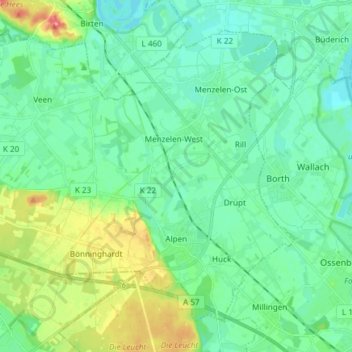
Name: Alpen topographic map, elevation, terrain.
Location: Alpen, Kreis Wesel, Nordrhein-Westfalen, 46519, Deutschland (51.55482 6.41375 51.63179 6.56314)
Average elevation: 28 m
Minimum elevation: 12 m
Maximum elevation: 75 m
Other topographic maps
Click on a map to view its topography, its elevation and its terrain.
Bönninghardt
Deutschland > Nordrhein-Westfalen > Kreis Wesel > Alpen > Bönninghardt
Bönninghardt, Alpen, Kreis Wesel, Nordrhein-Westfalen, 46519, Deutschland
Average elevation: 42 m