
Impasugong topographic map
Interactive map
Click on the map to display elevation.
About this map
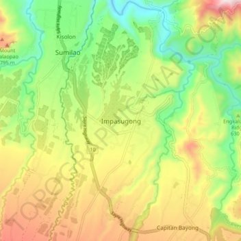
Name: Impasugong topographic map, elevation, terrain.
Location: Impasugong, Bukidnon, Northern Mindanao, Philippines (8.26605 124.95754 8.34605 125.03754)
Average elevation: 613 m
Minimum elevation: 323 m
Maximum elevation: 993 m
Cool and moist throughout the year due to its high elevation ranging from 500 metres (1,600 ft) to more than 1,000 metres (3,300 ft) above sea level. It is a typhoon-free area ideal for the production of high value crops. Average temperature ranges from 16 to 31 °C (61 to 88 °F) throughout the year.
Other topographic maps
Click on a map to view its topography, its elevation and its terrain.
Impasugong
Philippines > Bukidnon > Impasugong
Impasugong, Bukidnon, Northern Mindanao, 8702, Philippines
Average elevation: 903 m
Impalutao
Philippines > Bukidnon > Impasugong
Impalutao, Impasugong, Bukidnon, Northern Mindanao, 8702, Philippines
Average elevation: 769 m