
Make a donation
Rocky Knob topographic map
Click on the map to display elevation.
Make a donation
About this map
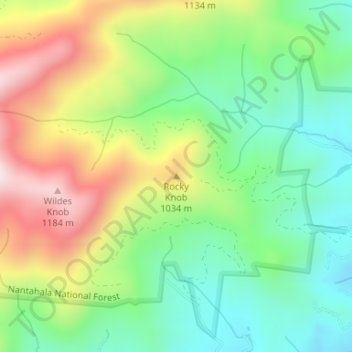
Name: Rocky Knob topographic map, elevation, terrain.
Location: Rocky Knob, Macon County, North Carolina, United States (35.23282 -83.51188 35.23292 -83.51178)
Average elevation: 875 m
Minimum elevation: 666 m
Maximum elevation: 1,203 m
Make a donation
Other topographic maps
Click on a map to view its topography, its elevation and its terrain.
Nantahala National Forest
United States > North Carolina > Macon County
The terrain varies in elevation from 5,800 feet (1,767.8 m) at Lone Bald in Jackson County, to 1,200 feet (365.8 m) in Cherokee County along the Hiwassee River below the Appalachia Dam. It is the home of many western NC waterfalls. The last part of the Mountain Waters Scenic Byway travels through this forest.…
Average elevation: 781 m
Little Tennessee River
United States > North Carolina > Macon County > Franklin > East Franklin
Average elevation: 641 m