
St. Kilian topographic map
Interactive map
Click on the map to display elevation.
About this map
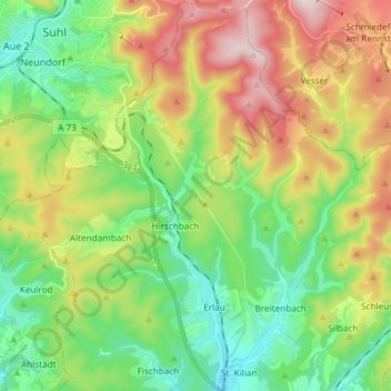
Name: St. Kilian topographic map, elevation, terrain.
Average elevation: 571 m
Minimum elevation: 386 m
Maximum elevation: 889 m
Other topographic maps
Click on a map to view its topography, its elevation and its terrain.
Talsperre Ratscher
Deutschland > Thüringen > Schleusingen
Talsperre Ratscher, Seeweg, Heckengereuth, Schleusingen, Landkreis Hildburghausen, Thüringen, 98553, Deutschland
Average elevation: 431 m