
Peck topographic map
Interactive map
Click on the map to display elevation.
About this map
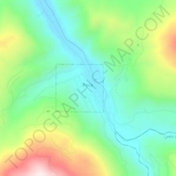
Name: Peck topographic map, elevation, terrain.
Location: Peck, Nez Perce County, Idaho, United States (46.47103 -116.43147 46.47837 -116.42075)
Average elevation: 492 m
Minimum elevation: 299 m
Maximum elevation: 878 m
Other topographic maps
Click on a map to view its topography, its elevation and its terrain.
Lewiston
United States > Idaho > Nez Perce County
Lewiston, Nez Perce County, Idaho, 83501, United States
Average elevation: 334 m
Lenore
United States > Idaho > Nez Perce County
Lenore, Nez Perce County, Idaho, United States
Average elevation: 401 m
Lapwai
United States > Idaho > Nez Perce County
Lapwai, Nez Perce County, Idaho, 83540, United States
Average elevation: 364 m
Culdesac
United States > Idaho > Nez Perce County > Culdesac
Culdesac, Nez Perce County, Idaho, United States
Average elevation: 588 m
Upper Cache Creek Rapids
United States > Idaho > Nez Perce County
Upper Cache Creek Rapids, Nez Perce County, Idaho, United States
Average elevation: 484 m