
Karode topographic map
Interactive map
Click on the map to display elevation.
About this map
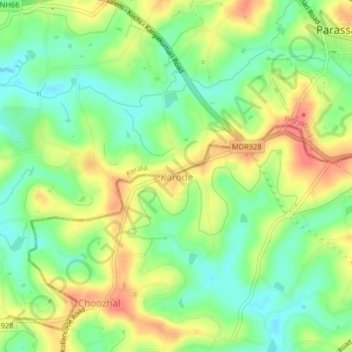
Name: Karode topographic map, elevation, terrain.
Average elevation: 42 m
Minimum elevation: 12 m
Maximum elevation: 78 m
Other topographic maps
Click on a map to view its topography, its elevation and its terrain.
Kadayal
India > Tamil Nadu > Vilavancode
Kadayal, Vilavancode, Kanyakumari District, Tamil Nadu, 629101, India
Average elevation: 72 m
Poothurai
India > Tamil Nadu > Vilavancode
Poothurai, Vilavancode, Kanyakumari District, Tamil Nadu, 629176, India
Average elevation: 7 m