
Chepachet topographic map
Interactive map
Click on the map to display elevation.
About this map
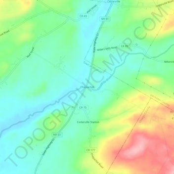
Name: Chepachet topographic map, elevation, terrain.
Average elevation: 408 m
Minimum elevation: 362 m
Maximum elevation: 500 m
Other topographic maps
Click on a map to view its topography, its elevation and its terrain.
Birmingham Corners
United States > New York > Herkimer County > Town of Winfield
Birmingham Corners, Town of Winfield, Herkimer County, New York, 13491, United States
Average elevation: 417 m
Woods Corners
United States > New York > Herkimer County > Town of Winfield
Woods Corners, Town of Winfield, Herkimer County, New York, 13491, United States
Average elevation: 418 m
Cedarville Station
United States > New York > Herkimer County > Town of Winfield
Cedarville Station, Town of Winfield, Herkimer County, New York, United States
Average elevation: 412 m