
Thank you for supporting this site ❤️
Make a donation
Make a donation
Huacullani topographic map
Click on the map to display elevation.
Thank you for supporting this site ❤️
Make a donation
Make a donation
About this map
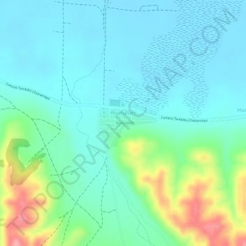
Name: Huacullani topographic map, elevation, terrain.
Location: Huacullani, Tiahuanacu, Ingavi, La Paz, Bolivia (-16.44636 -68.74330 -16.44089 -68.73649)
Average elevation: 3,847 m
Minimum elevation: 3,816 m
Maximum elevation: 3,935 m
Thank you for supporting this site ❤️
Make a donation
Make a donation
Other topographic maps
Click on a map to view its topography, its elevation and its terrain.