
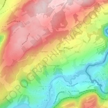
La Courpée topographic map
Interactive map
Click on the map to display elevation.
About this map
Name: La Courpée topographic map, elevation, terrain.
Average elevation: 923 m
Minimum elevation: 744 m
Maximum elevation: 1,086 m
Other topographic maps
Click on a map to view its topography, its elevation and its terrain.
Les Combottes
France > Bourgogne-Franche-Comté > Doubs > Villers-le-Lac
Les Combottes, Villers-le-Lac, Pontarlier, Doubs, Bourgogne-Franche-Comté, France métropolitaine, 25130, France
Average elevation: 930 m
L'Essart Fourgan
France > Bourgogne-Franche-Comté > Doubs > Villers-le-Lac
L'Essart Fourgan, Villers-le-Lac, Pontarlier, Doubs, Bourgogne-Franche-Comté, France métropolitaine, 25130, France
Average elevation: 910 m
Les Pargots
France > Bourgogne-Franche-Comté > Doubs > Villers-le-Lac
Les Pargots, Villers-le-Lac, Pontarlier, Doubs, Bourgogne-Franche-Comté, France métropolitaine, 25130, France
Average elevation: 913 m
Sur la Roche
France > Bourgogne-Franche-Comté > Doubs > Villers-le-Lac
Sur la Roche, Villers-le-Lac, Pontarlier, Doubs, Bourgogne-Franche-Comté, France métropolitaine, 25130, France
Average elevation: 1,038 m