
Kingston topographic map
Interactive map
Click on the map to display elevation.
About this map
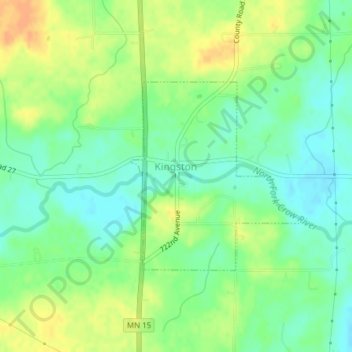
Name: Kingston topographic map, elevation, terrain.
Location: Kingston, Meeker County, Minnesota, United States (45.18891 -94.31824 45.20338 -94.29896)
Average elevation: 323 m
Minimum elevation: 308 m
Maximum elevation: 341 m
Other topographic maps
Click on a map to view its topography, its elevation and its terrain.
Jennie
United States > Minnesota > Meeker County
Jennie, Collinwood Township, Meeker County, Minnesota, United States
Average elevation: 333 m
North Side Mobile Home Park
United States > Minnesota > Meeker County > Grove City
North Side Mobile Home Park, Grove City, Meeker County, Minnesota, 56243, United States
Average elevation: 363 m
Litchfield
United States > Minnesota > Meeker County
Litchfield, Meeker County, Minnesota, 55355, United States
Average elevation: 344 m
Dassel
United States > Minnesota > Meeker County
Dassel, Meeker County, Minnesota, 55325, United States
Average elevation: 333 m