
Fultondale topographic map
Interactive map
Click on the map to display elevation.
About this map
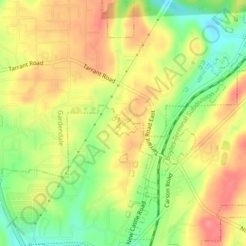
Name: Fultondale topographic map, elevation, terrain.
Location: Fultondale, Jefferson County, Alabama, United States (33.63460 -86.78918 33.63555 -86.78769)
Average elevation: 190 m
Minimum elevation: 147 m
Maximum elevation: 224 m
Due to difficult topography, for many years Fultondale was limited in its ability to grow. However, as technology improved, the ability to convert what had been difficult to unusable land for retail and commercial purposes improved. Besides the retail development of Colonial Promenade, other retail development nearby includes Lowe's and various chain restaurants such as O'Charley's and Outback Steakhouse. Other older, more mature business establishments line US 31 in the center of the community including supermarkets, casual fast food, banks, a bowling alley and skating rink.
Other topographic maps
Click on a map to view its topography, its elevation and its terrain.
Frances Heights
United States > Alabama > Jefferson County > Fultondale
Frances Heights, Fultondale, Jefferson County, Alabama, 35068, United States
Average elevation: 174 m