
Thank you for supporting this site ❤️
Make a donation
Make a donation
Lima Kedai topographic map
Click on the map to display elevation.
Thank you for supporting this site ❤️
Make a donation
Make a donation
About this map
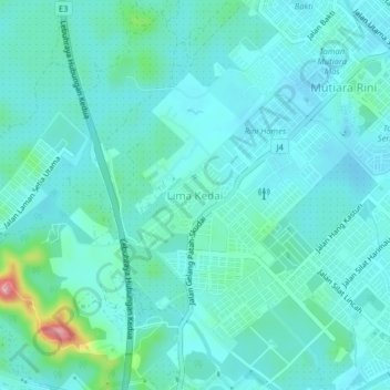
Name: Lima Kedai topographic map, elevation, terrain.
Average elevation: 31 m
Minimum elevation: 8 m
Maximum elevation: 154 m
Thank you for supporting this site ❤️
Make a donation
Make a donation
Other topographic maps
Click on a map to view its topography, its elevation and its terrain.
Thank you for supporting this site ❤️
Make a donation
Make a donation
Thank you for supporting this site ❤️
Make a donation
Make a donation
Thank you for supporting this site ❤️
Make a donation
Make a donation
Bandar Gelang Patah
Malaysia > Johor > Iskandar Puteri > Gelang Patah > Bandar Gelang Patah
Average elevation: 11 m