
Northallerton topographic map
Interactive map
Click on the map to display elevation.
About this map
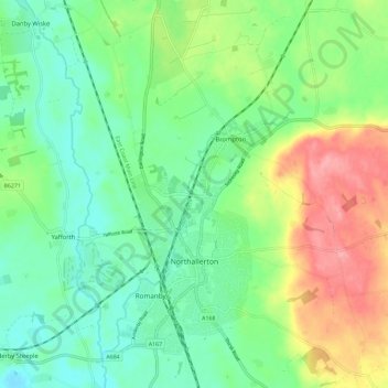
Name: Northallerton topographic map, elevation, terrain.
Average elevation: 56 m
Minimum elevation: 23 m
Maximum elevation: 116 m
Other topographic maps
Click on a map to view its topography, its elevation and its terrain.
Thornton-on-the-Hill
United Kingdom > England > North Yorkshire > Hambleton
Thornton-on-the-Hill, Hambleton, North Yorkshire, England, United Kingdom
Average elevation: 80 m
Stokesley
United Kingdom > England > North Yorkshire > Hambleton
Stokesley, Hambleton, North Yorkshire, England, United Kingdom
Average elevation: 74 m
Exelby, Leeming and Londonderry
United Kingdom > England > North Yorkshire > Hambleton
Exelby, Leeming and Londonderry, Hambleton, North Yorkshire, Yorkshire and the Humber, England, United Kingdom
Average elevation: 35 m
Great Ayton
United Kingdom > England > North Yorkshire > Hambleton > Great Ayton
Great Ayton, Hambleton, North Yorkshire, Yorkshire and the Humber, England, United Kingdom
Average elevation: 119 m
Howe
United Kingdom > England > North Yorkshire > Hambleton > Skipton on Swale > Howe
Howe, Skipton on Swale, Hambleton, North Yorkshire, Yorkshire and the Humber, England, YO7 4HU, United Kingdom
Average elevation: 28 m