
Thank you for supporting this site ❤️
Make a donation
Make a donation
Cat Island topographic map
Click on the map to display elevation.
Thank you for supporting this site ❤️
Make a donation
Make a donation
About this map
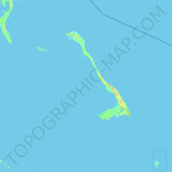
Name: Cat Island topographic map, elevation, terrain.
Location: Cat Island, The Bahamas (23.78122 -76.17056 24.89600 -75.07317)
Average elevation: 0 m
Minimum elevation: -4 m
Maximum elevation: 58 m
Thank you for supporting this site ❤️
Make a donation
Make a donation
Other topographic maps
Click on a map to view its topography, its elevation and its terrain.