
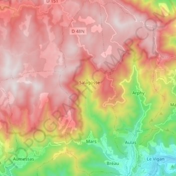
Bréau-et-Salagosse topographic map
Interactive map
Click on the map to display elevation.
About this map
Name: Bréau-et-Salagosse topographic map, elevation, terrain.
Average elevation: 924 m
Minimum elevation: 213 m
Maximum elevation: 1,428 m
Other topographic maps
Click on a map to view its topography, its elevation and its terrain.
L'Elzière
France > Occitanie > Gard > Bréau-Mars
L'Elzière, Mars, Bréau-Mars, Le Vigan, Gard, Occitanie, France métropolitaine, 30120, France
Average elevation: 637 m
Mars
France > Occitanie > Gard > Bréau-Mars
Mars, Bréau-Mars, Le Vigan, Gard, Occitanie, France métropolitaine, 30120, France
Average elevation: 702 m