
Sorifa topographic map
Interactive map
Click on the map to display elevation.
About this map
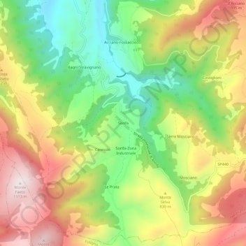
Name: Sorifa topographic map, elevation, terrain.
Location: Sorifa, Nocera Umbra, Perugia, Umbria, 06025, Italia (43.05934 12.80139 43.09934 12.84139)
Average elevation: 768 m
Minimum elevation: 460 m
Maximum elevation: 1,111 m
Other topographic maps
Click on a map to view its topography, its elevation and its terrain.
Le Prata
Italia > Umbria > Perugia > Nocera Umbra
Le Prata, Nocera Umbra, Perugia, Umbria, 06025, Italia
Average elevation: 814 m