
Argentières topographic map
Interactive map
Click on the map to display elevation.
About this map
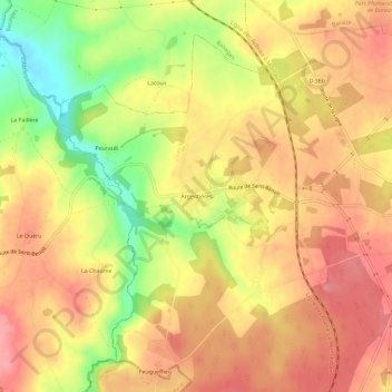
Name: Argentières topographic map, elevation, terrain.
Average elevation: 271 m
Minimum elevation: 210 m
Maximum elevation: 307 m
Other topographic maps
Click on a map to view its topography, its elevation and its terrain.
Éguzonnet
France > Centre-Val de Loire > Indre > Éguzon-Chantôme > Éguzonnet
Éguzonnet, Éguzon-Chantôme, Châteauroux, Indre, Centre-Val de Loire, France métropolitaine, 36270, France
Average elevation: 240 m