
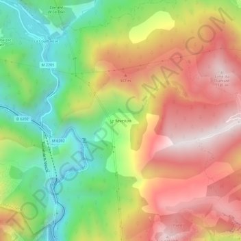
Le Reveston topographic map
Interactive map
Click on the map to display elevation.
About this map
Name: Le Reveston topographic map, elevation, terrain.
Average elevation: 661 m
Minimum elevation: 156 m
Maximum elevation: 1,184 m
Other topographic maps
Click on a map to view its topography, its elevation and its terrain.
Les Roures
France > Provence-Alpes-Côte d'Azur > Alpes-Maritimes > Utelle > Ripaïre
Les Roures, Ripaïre, Utelle, Nice, Alpes-Maritimes, Provence-Alpes-Côte d'Azur, France métropolitaine, 06450, France
Average elevation: 567 m
Callanques
France > Provence-Alpes-Côte d'Azur > Alpes-Maritimes > Utelle > Collet du Pape
Callanques, Collet du Pape, Utelle, Nice, Alpes-Maritimes, Provence-Alpes-Côte d'Azur, France métropolitaine, 06450, France
Average elevation: 733 m
Le Cros d'Utelle
France > Provence-Alpes-Côte d'Azur > Alpes-Maritimes > Utelle
Le Cros d'Utelle, Utelle, Nice, Alpes-Maritimes, Provence-Alpes-Côte d'Azur, France métropolitaine, 06450, France
Average elevation: 634 m
Les Granges de la Brasque
France > Provence-Alpes-Côte d'Azur > Alpes-Maritimes > Utelle
Les Granges de la Brasque, Utelle, Nice, Alpes-Maritimes, Provence-Alpes-Côte d'Azur, France métropolitaine, 06450, France
Average elevation: 1,640 m
Le Figaret
France > Provence-Alpes-Côte d'Azur > Alpes-Maritimes > Utelle
Le Figaret, Utelle, Nice, Alpes-Maritimes, Provence-Alpes-Côte d'Azur, France métropolitaine, 06450, France
Average elevation: 717 m
Le Chaudan
France > Provence-Alpes-Côte d'Azur > Alpes-Maritimes > Utelle > Le Chaudan
Le Chaudan, Utelle, Nice, Alpes-Maritimes, Provence-Alpes-Côte d'Azur, France métropolitaine, 06450, France
Average elevation: 491 m
Saint-Jean la Rivière
France > Provence-Alpes-Côte d'Azur > Alpes-Maritimes > Utelle
Saint-Jean la Rivière, Utelle, Nice, Alpes-Maritimes, Provence-Alpes-Côte d'Azur, France métropolitaine, 06450, France
Average elevation: 729 m
La Madone
France > Provence-Alpes-Côte d'Azur > Alpes-Maritimes > Utelle
La Madone, Utelle, Nice, Alpes-Maritimes, Provence-Alpes-Côte d'Azur, France métropolitaine, 06450, France
Average elevation: 617 m
Colombier
France > Provence-Alpes-Côte d'Azur > Alpes-Maritimes > Utelle
Colombier, Utelle, Nice, Alpes-Maritimes, Provence-Alpes-Côte d'Azur, France métropolitaine, 06450, France
Average elevation: 637 m
Séren
France > Provence-Alpes-Côte d'Azur > Alpes-Maritimes > Utelle
Séren, Utelle, Nice, Alpes-Maritimes, Provence-Alpes-Côte d'Azur, France métropolitaine, 06450, France
Average elevation: 631 m
La Villette
France > Provence-Alpes-Côte d'Azur > Alpes-Maritimes > Utelle
La Villette, Utelle, Nice, Alpes-Maritimes, Provence-Alpes-Côte d'Azur, France métropolitaine, 06450, France
Average elevation: 593 m