
Campandré-Valcongrain topographic map
Interactive map
Click on the map to display elevation.
About this map
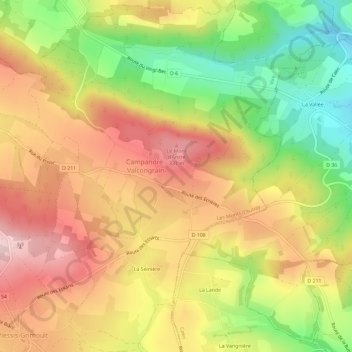
Name: Campandré-Valcongrain topographic map, elevation, terrain.
Average elevation: 238 m
Minimum elevation: 108 m
Maximum elevation: 348 m
Other topographic maps
Click on a map to view its topography, its elevation and its terrain.
Le Plessis-Grimoult
France > Normandie > Calvados > Les Monts d'Aunay
Le Plessis-Grimoult, Les Monts d'Aunay, Vire, Calvados, Normandie, France métropolitaine, 14770, France
Average elevation: 258 m
Les Monts d'Aunay
France > Normandie > Calvados > Les Monts d'Aunay > Les Monts d'Aunay
Les Monts d'Aunay, Vire, Calvados, Normandie, France métropolitaine, 14260, France
Average elevation: 151 m
La Grellerie
France > Normandie > Calvados > Les Monts d'Aunay > Aunay-sur-Odon
La Grellerie, Aunay-sur-Odon, Les Monts d'Aunay, Vire, Calvados, Normandie, France métropolitaine, 14260, France
Average elevation: 177 m
Ondefontaine
France > Normandie > Calvados > Les Monts d'Aunay
Ondefontaine, Les Monts d'Aunay, Vire, Calvados, Normandie, France métropolitaine, 14260, France
Average elevation: 238 m
Aunay-sur-Odon
France > Normandie > Calvados > Les Monts d'Aunay
Aunay-sur-Odon, Les Monts d'Aunay, Vire, Calvados, Normandie, France métropolitaine, 14260, France
Average elevation: 172 m
Mont Pinçon
France > Normandie > Calvados > Les Monts d'Aunay
Mont Pinçon, Les Monts d'Aunay, Vire, Calvados, Normandie, France métropolitaine, 14770, France
Average elevation: 281 m