
Nyanza topographic map
Interactive map
Click on the map to display elevation.
About this map
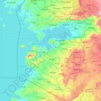
Name: Nyanza topographic map, elevation, terrain.
Location: Nyanza, Kenya (-1.38938 33.92540 0.31102 35.34333)
Average elevation: 1,411 m
Minimum elevation: 1,128 m
Maximum elevation: 2,563 m
Other topographic maps
Click on a map to view its topography, its elevation and its terrain.
Kisumu
Kenya > Kisumu County > Kisumu Central
Its elevation is 1,131 m (3,711 ft) above sea level. Kisumu is about 320 km (200 mi) northwest of Nairobi and is located on the shores of Lake Victoria. It lies at the northeastern edge of the Winam Gulf, a long, shallow arm that protrudes from the main body of Lake Victoria. Kisumu is 24 km (15 mi) south of…
Average elevation: 1,219 m
Nyeri
Nyeri has tarmacked roads, and the county and national government are upgrading many of them. Houses have drinking water on tap, but sewage provision through soak pits, pit latrines and septic tanks is still widespread. The city's topography allows nature and gravity to take care of most of the city's storm…
Average elevation: 1,796 m