
Thank you for supporting this site ❤️
Make a donation
Make a donation
Chef du Pont topographic map
Click on the map to display elevation.
Thank you for supporting this site ❤️
Make a donation
Make a donation
About this map
Name: Chef du Pont topographic map, elevation, terrain.
Average elevation: 37 m
Minimum elevation: 0 m
Maximum elevation: 89 m
Thank you for supporting this site ❤️
Make a donation
Make a donation
Other topographic maps
Click on a map to view its topography, its elevation and its terrain.
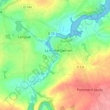
Pommerit-Jaudy
France > Bretagne > Côtes-d'Armor > La Roche-Jaudy
Selon l'Institut national de l'information géographique et forestière, la superficie de la commune est de 2 037 ha ; son altitude varie entre 2 et 94 m.
Average elevation: 60 m
Thank you for supporting this site ❤️
Make a donation
Make a donation