
Thank you for supporting this site ❤️
Make a donation
Make a donation
Utuado topographic map
Click on the map to display elevation.
Thank you for supporting this site ❤️
Make a donation
Make a donation
Utuado
During the late 18th and early 19th centuries, Utuado's population continued to grow as coffee gained in importance and growers saw the need for high altitudes and mountainous terrain to produce the best coffee beans. People not only migrated from the Puerto Rican coastal towns but also from Ireland (founder Sebastian de Morfi was Irish), the Canary Islands and the Balearic Islands of Majorca and Menorca, all seeking the riches that coffee had to offer.
Thank you for supporting this site ❤️
Make a donation
Make a donation
About this map
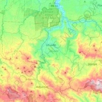
Name: Utuado topographic map, elevation, terrain.
Location: Utuado, Puerto Rico, United States (18.15069 -66.83125 18.34970 -66.56656)
Average elevation: 481 m
Minimum elevation: 23 m
Maximum elevation: 1,303 m
Thank you for supporting this site ❤️
Make a donation
Make a donation