
Kuppe topographic map
Interactive map
Click on the map to display elevation.
About this map
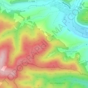
Name: Kuppe topographic map, elevation, terrain.
Average elevation: 348 m
Minimum elevation: 238 m
Maximum elevation: 486 m
Other topographic maps
Click on a map to view its topography, its elevation and its terrain.
Remda-Teichel
Deutschland > Thüringen > Rudolstadt
Remda-Teichel, Rudolstadt, Landkreis Saalfeld-Rudolstadt, Thüringen, Deutschland
Average elevation: 407 m
Unterpreilipp
Deutschland > Thüringen > Rudolstadt > Unterpreilipp
Unterpreilipp, Rudolstadt, Saalfelder Höhe, Landkreis Saalfeld-Rudolstadt, Thüringen, 07407, Deutschland
Average elevation: 268 m