
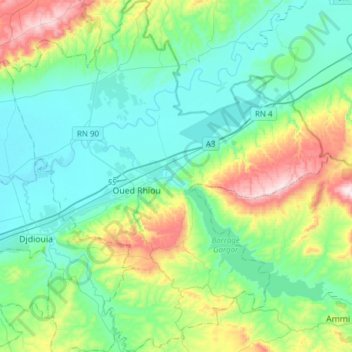
Daïra Oued Rhiou topographic map
Interactive map
Click on the map to display elevation.
About this map
Name: Daïra Oued Rhiou topographic map, elevation, terrain.
Location: Daïra Oued Rhiou, Relizane, Algérie (35.84646 0.80179 36.09408 1.08502)
Average elevation: 196 m
Minimum elevation: 42 m
Maximum elevation: 692 m
Other topographic maps
Click on a map to view its topography, its elevation and its terrain.
Oued Rhiou
Algérie > Relizane > Daïra Oued Rhiou
Oued Rhiou, Daïra Oued Rhiou, Relizane, Algérie
Average elevation: 143 m