
Vijayanagara topographic map
Interactive map
Click on the map to display elevation.
About this map
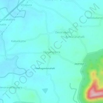
Name: Vijayanagara topographic map, elevation, terrain.
Average elevation: 624 m
Minimum elevation: 587 m
Maximum elevation: 862 m
Other topographic maps
Click on a map to view its topography, its elevation and its terrain.
Kenchenahalli
India > Karnataka > Bhadravati taluk
Kenchenahalli, Bhadravati taluk, Shimoga District, Karnataka, India
Average elevation: 619 m
Hosahalli
India > Karnataka > Bhadravati taluk
Hosahalli, Bhadravati taluk, Shimoga district, Karnataka, 577233, India
Average elevation: 595 m