
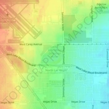
Carey–Lake Mead Detention Basin topographic map
Interactive map
Click on the map to display elevation.
About this map
Name: Carey–Lake Mead Detention Basin topographic map, elevation, terrain.
Average elevation: 648 m
Minimum elevation: 627 m
Maximum elevation: 670 m
Other topographic maps
Click on a map to view its topography, its elevation and its terrain.
Lovell
United States > Nevada > Clark County > North Las Vegas
Lovell, North Las Vegas, Clark County, Nevada, 89115, United States
Average elevation: 646 m
Craig Ranch Regional Park
United States > Nevada > Clark County > North Las Vegas
Craig Ranch Regional Park, 628, Craig Ranch, North Las Vegas, Clark County, Nevada, 89032, United States
Average elevation: 626 m
Eldorado Park
United States > Nevada > Clark County > North Las Vegas
Eldorado Park, North Las Vegas, Clark County, Nevada, United States
Average elevation: 646 m
North Las Vegas
United States > Nevada > Clark County > North Las Vegas
North Las Vegas, Clark County, Nevada, 89030, United States
Average elevation: 677 m