
Village of Cayuga Heights topographic map
Interactive map
Click on the map to display elevation.
About this map
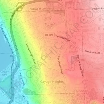
Name: Village of Cayuga Heights topographic map, elevation, terrain.
Average elevation: 234 m
Minimum elevation: 114 m
Maximum elevation: 311 m
Cayuga Heights is located at 42°27′59″N 76°29′19″W / 42.466338°N 76.488678°W / 42.466338; -76.488678 (42.466338, -76.488678), on the eastern slope of Cayuga Lake. The elevation ranges from 900 feet near the Community Corners to 400 feet near the lake. Several streams and steep gorges cut through the village.