
Thank you for supporting this site ❤️
Make a donation
Make a donation
Hochalm topographic map
Click on the map to display elevation.
Thank you for supporting this site ❤️
Make a donation
Make a donation
About this map
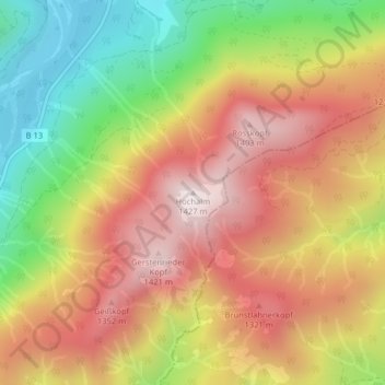
Name: Hochalm topographic map, elevation, terrain.
Average elevation: 1,085 m
Minimum elevation: 699 m
Maximum elevation: 1,418 m
Thank you for supporting this site ❤️
Make a donation
Make a donation
Other topographic maps
Click on a map to view its topography, its elevation and its terrain.
Sylvensteinspeicher
Deutschland > Bayern > Landkreis Bad Tölz-Wolfratshausen > Lenggries > Fall
Der Stausee wurde nach dem Sylvenstein benannt, einem Felsrücken, der im oberen Isartal eine natürliche Engstelle nach Osten begrenzt. Die westliche Begrenzung ist das felsige Hennenköpfl. Der Sylvensteinsee ist auch ein Ausflugsziel und Erholungsgebiet. Im See versunken liegt das ehemalige Dorf Fall, das…
Average elevation: 955 m